Welcome to Sedona part #4 (or for Judith, Sedona part 8)!
This trip got off to an “interesting” start. Saturday morning as I was getting ready to print our boarding passes I noticed there had been a “schedule change” on our flights… Instead of leaving at 1 PM and arriving in Phoenix at 5 PM (MST), we were now to leave at 4:00 have a 4 hour lay-over in Atlanta and arrive in Phoenix shortly before midnight. Of course then we would need to get a car & drive the 2 hours to Sedona (oh, and don’t forget about the 3 hour time difference!)
Delta re-arranged our prepaid Priceline tickets so that we flew out of Cleveland (instead of Akron-Canton) and arrived in Phoenix at 6 PM! A little nerve-wracking, but thank-you Delta!
It was 94 degrees in Phoenix when we landed; but was a pleasant 65 when we got to Sedona.
Sunday was somewhat overcast and hazy – not the Sedona Blue skys we normally experience. We decided to take a modest hike, but a new one for us. After we finally found the trail-head, it was a lovely hike – just right to get back into the groove. Also, this is the time of year that many of the desert plants are blooming (just like at home) and we saw some lovely little blooms.


Monday – A little sight-seeing is in order. We drove up the lovely, winding highway through Oak Creek Canyon to Flagstaff (elevation 7,000 ft). Approaching town we noticed that some of the people along the street had on heavy jackets, and the car’s outdoor thermometer was reading 47 degrees. While this would not normally be a huge problem, Judith had managed to lose her rain jacket in the Atlanta airport, and had not brought her heavy sweater either. Fortunately, Flagstaff is a college town. We parked just off of historic San Francisco street and found 5 outdoor outfitters within just a few blocks! New jacket in hand, we were on our way!
First stop, Sunset Crater Volcano. The eruption of this volcano occurred about 1,000 years ago, and the surrounding area is still largely barren, with mounds of lava and cinders. In fact, after we left the Crater, the ground was mostly covered with cinders 20 miles away even yet! The lack of moisture in Arizona’s high desert has resulted in the extremely slow erosion of the lava. It was awe inspiring and mind boggling to contemplate. Oh, and yes, that is snow on the top of Mt. San Francisco the first week of May.


Then on to the Indian ruins… What does one say about the ruins of a 100 room pueblo, built 800 – 900 years ago in the high desert where water was always at a premium and life could not possibly have been easy? It is wonder-ful.


Hope you enjoyed this part of our trip (and Judith’s finger).
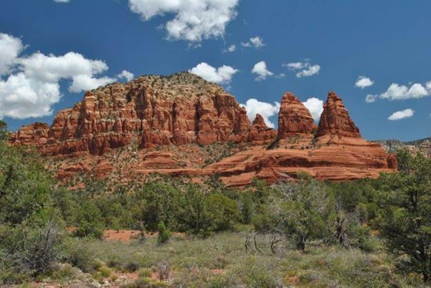
Tuesday, we took our favorite Sedona hike – Mitten Ridge. This area is considered by many to be a Vortex Site; but is not on most of the lists of Vortex sites in the area. For me, for us, this is the most spectacular, mountain top experience ever. The peace and serenity, the grandeur, the immensity of the world and our place in it, combine to nearly overwhelm us.
Access to this trail is a little “interesting”. One takes Schnebly Hill Road about 6 miles up the side of the canyon wall to reach the Trail Head. One can actually take this road all the way up to the top of the rim and access I-17 – if you have the fortitude to do so. After the first half-mile of the road, the pavement ENDS. From there on it is dirt and rocks! We met two local men who had just completed the Mitten Ridge hike as we reached the Trail Head parking and were discussing this. One commented that the 11 mile drive from I-17 to Sedona via Schnebly Hill Road would be the longest 11 miles one would ever drive! We averaged less than 10 m.p.h. up this road. But the hike is worth every body shaking bump in getting there!


After our hike and lunch, we visited another of our favorite sites: Woo Ranch, home to some amazing Sinaugua rock art. And this is a site that even most well informed locals do not know about. This property is now part of the Forest Service lands and as such is “accessible” to the public for hiking, etc. Accessible is a relative term since you must shimmy under a locked gate or crawl through a barbed-wire fence to enter. However, we discovered that it was guarded by even more threatening defenses – the “Attack of the Prickley Pear”!
As we were climbing the hill to reach the rock art (protected by a sign saying “Don’t deface Cultural Heritage sites”), Judith lost her balance and accidentally sat down onto a Prickly Pear Cactus! She had (and in some cases, still has) cactus spines just about “everywhere”!


Wednesday we visited Enchantment Resort. This is a very high-end resort in the basin of Boynton Canyon. We ate on the patio with the red-rock of the canyon walls as our entertainment. The food was good, the surroundings were spectacular.


Thursday – After our (mis-?)adventures on Wednesday, we decided a “new’ hike was in order, and it was my turn to choose. I selected a hike that the books listed as a “Personal Favorite” and that was a little off the beaten path so we could enjoy the peace of nature. By a little off the beaten path, I’m saying 3 miles down FR 152-C (FR = Fire Road). In the past this has been a minimally maintained road (also known as Vultee Arch Road) that provided access to several well liked hikes. However, it has been “downgraded” to a “high clearance vehicle” road only. We had rented a Kia Soul that had 6 ½” ground clearance (rather than the 5” of most passenger cars) and hoped that we qualified, since we only scraped “a little” going over the rocks marking the beginning of the unmaintained section.
The first 2+ miles were bumpy (Judith questioned whether her innards would ever return to their normal locations!) Then came “the chasm”; a combination of rocks sticking 8 – 12 inches above the roadbed, combined with gullys 18” deep. We decided that discretion was the better part of valor, backed up to a turn out and parked there.
From there we walked the remaining ¾ mile to the Trail Head and started the trail. While it was a pleasant hike, it was not spectacular, and by the time we had walked another ¾ mile we decided to return to the car. It was a nice hike, but the views were mostly better from the road than from the trail, although we did see some manzinita in bloom, which was lovely.


After our morning hike we bought a picnic lunch and headed to Crescent Moon Park, the site of the classic pictures of Cathedral Rock. It is a lovely park, it does have great views of Cathedral Rock, and we enjoyed just dawdling around the pleasant trails & stream and looking at this classic Sedona site.


Friday was going to be our last day in Sedona, and Judith let me pick the hike again (as long as we stayed on “real” roads). We had seen a trail marker from the road that was fairly near our lodging and decided that would be a good choice. Boy, were we RIGHT! It is now among our favorite Sedona hikes! Little Horse Trail is near the highway and very close to Bell Rock, another of the Sedona icons. Along the way, we had good views of Bell Rock, Courthouse Butte, and Cathedral Rock, as well as many less well known formations (one I called “Shark’s Teeth”, but that’s not on the maps either.)
While this trail was not extremely strenuous, we did need to stop to catch our breath a few times. This trail is also a mountain-biking trail – although I really don’t see how “I” could possibly manage the steep inclines, boulders, etc. that are a part of this trail on a bicycle… but there were those who did.
The trail ends at “Chicken Point”. I don’t know where the name comes from, but the views were spectacular. When we arrived at this huge, slick rock outcropping, there was about a dozen hikers gathered around, hugging one another, etc. When we approached, they advised us that a couple from their hiking group had just become engaged right there. We often meet the most pleasant people hiking, and here it was again!
We were again struck by the beauty of the red rock area, and the grandeur of the sites. To give a sense of perspective, can you find Judith in the third picture below? She’s wearing red, so she should stand out easily, right?


Following the hike we stopped at the Hillside Shops to look at some of the interesting sculptures on display in their parking lot.


Then we went into Sedona for lunch/dinner at The Cowboy Club. We were once again struck by the beauty of Red Rock country, but also by the accessibility of the views. While we enjoy hiking and getting into the back country, one can also see spectacular views – even from a downtown parking lot.

We took a little nap before starting our trek home. We left Sedona about 7:30 in the evening, drove to Phoenix to return the (unbroken) car, and catch our 11:25 PM flight to Detroit, with a 6 hour layover and plane and terminal change before hopping on to Cleveland. It was a great trip, but we were tired by the time we got home around 2:30 Saturday afternoon!
But we can’t wait to do it all again! This place is magical for us; we never get tired of it and we ooh and aah over the same vistas every day! Thanks for joining us on our trip!
Judith and Mark